Fell Top Conditions on Wednesday 19 February
Readings from Helvellyn summit at 09:50
Temperature minus 1.1°C Maximum wind speed 46.7mph Wind chill minus 11.2°C Average wind speed 22.2mph Wind direction S
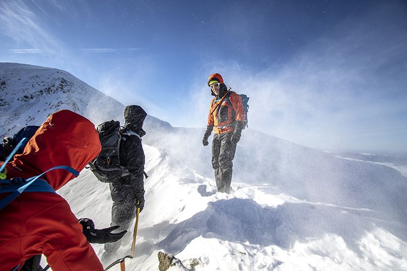
An early start today paid off on Helvellyn in order to catch the crisp and well frozen snow conditions we have got used to of late! Conditions under foot remained the same with swathes of hard snow-ice coating most high level routes and the need for full winter clothing and axes/crampons. There was a marked change in the weather by midday with rain/sleet starting to blow in and an increase in wind as well as a drop in the cloud base, so in all a change to more challenging weather conditions on the fells.
Currently we are seeing the transition to slightly damper conditions, however the temperatures remain relatively low meaning the need for good winter clothing and layers is still a must, additionally the hard snow-ice and areas of lying water-ice that we have seen building over the last week will be slow to change and the need for caution on areas of steep or exposed snow will continue, and crampons and axes will still be essential on many high or exposed routes, and micro-spikes would be advisable even on the easier high level routes. As well as full winter clothing and safety equipment, with lower cloud now, the need for maps and compasses and the knowledge of how to use them is essential.
Hopefully another freeze will follow and good winter conditions will continue on the fells soon!
Lake District weather forecast for Thursday 20 February
See today's weather conditions on live Lake District webcams
Issued: 19 February at 17:25
Very windy conditions with heavy rain, perhaps thundery. Drier and brighter later.
Lake District Weather
Cloudy with outbreaks of rain or drizzle accompanied by very strong and gusty winds. The rain is likely to be heavy at times with a chance of hail and thunder, especially around the middle of the day. Drier with bright or clear spells developing from around mid-afternoon onwards with a few showers.
Visibility
Extensive cloud down to low slopes overnight and to start the day, rising to about 600m by early afternoon and becoming patchier, mainly affecting southern and western fells. Visibility often poor through the morning with some navigational difficulties, becoming mainly good by mid-afternoon.
Chance of Cloud Free Hill Top
10%, improving to 80% during the afternoon.
Thursday's forecast:
| Time | 00:00 - 03:00 | 03:00 - 06:00 | 06:00 - 09:00 | 09:00 - 12:00 | 12:00 - 15:00 | 15:00 - 18:00 |
 |
 |
 |
 |
 |
 | |
| Chance of precipitation | 40% | 40% | 40% | 70% | >95% | 30% |
| At Valley | ||||||
| Temp | 7 | 8 | 9 | 10 | 10 | 9 |
| Wind (mph) | 14 | 13 | 14 | 18 | 21 | 14 |
| Max gusts (mph) | 35 | 32 | 35 | 41 | 47 | 31 |
| Wind direction | SE | S | S | S | S | SW |
| At 300m | ||||||
| Temp | 6 | 6 | 8 | 9 | 9 | 8 |
| Wind (mph) | 14 | 11 | 12 | 16 | 17 | 14 |
| Max gusts (mph) | 38 | 32 | 35 | 42 | 46 | 34 |
| Wind direction | S | S | S | S | S | SW |
| At 600m | ||||||
| Temp | 4 | 5 | 6 | 8 | 7 | 6 |
| Wind (mph) | 38 | 36 | 36 | 36 | 41 | 31 |
| Max gusts (mph) | 53 | 50 | 51 | 51 | 58 | 43 |
| Wind direction | S | S | S | S | S | SW |
| At 900m | ||||||
| Temp | 3 | 5 | 6 | 6 | 5 | 4 |
| Wind (mph) | 45 | 44 | 44 | 47 | 53 | 39 |
| Max gusts (mph) | 57 | 55 | 55 | 60 | 68 | 51 |
| Wind direction | S | S | S | S | S | SW |
Daylight
Provided by time.isLake District Forecast for Friday
Dry at first overnight then periods of heavy rain by dawn and continuing through most of the day. Combination of heavy rain and very strong winds bringing serious conditions with walking almost impossible on high slopes. Rain and winds easing towards the very end of the day.
Visibility
Generally poor visibility for most of the day with areas of cloud and fog above 600m and patches to lower slopes in the south. Improving late in the day but still some cloud above 600m.
Chance of cloud free hill
10%, becoming 40% late in day.
Wind
Southerly 50 to 60mph gusts 80 to 90mph, easing 30mph gusts 45mph towards evening.
Temperatures
- Valley: Plus 10 to 12C.
- At 800m: Plus 6 or 7C.
- Freezing level: Above summits.
Outlook for next few days
Saturday 22 February
Dry with bright or sunny spells but some patchy low cloud, mainly over western fells. Fresh to strong southwesterly winds with freezing level above summits. Likely to be the driest day of the period.
Sunday 23 February
Very unsettled with heavy and persistent rain. Severe gale or storm force southwest winds.
Monday 24 February
Sunny spells and occasional showers, wintry on the highest summits. Fresh westerly winds. A little colder.
An overview of weather in the Lake District
Summer:
The summer season in the Lake District actually runs from March to October. The driest period runs between March and June.
The weather is renowned for changing rapidly and rainfall is a predominant feature. The wettest area in the Lake District is known as Sprinkling Tarn which receives approximately 5000mm of rainfall every year!
Winter:
The wettest months run from October to January.
Snowfall typically falls from November to March. The valleys of the Lake District receive around 20 days of snow and 200 days of rain per year.


